
Dublin Core
Identifier
1544
Title
Narragansett Bay, Rhode Island 1777
Description
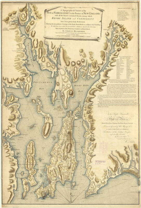
A topographical chart of the bay of Narraganset in the province of New England : with all the isles contained therein, among which Rhode Island and Connonicut have been particularly surveyed, shewing the true position & bearings of the banks, shoals, rocks &c. as likewise the soundings; To which have been added the several works & batteries raised by the Americans. Taken by order of the principal farmers on Rhode Island
Hand colored ; Relief shown by hachures. Depths shown by soundings ; Inscribed "To the Right Honourable Hugh Earl Percy ... with His Lordship's permission ... by ... Wm. Faden." ; Includes text, "References to the batteries," and "A list of the principal farms in Rhode Island."
Hand colored ; Relief shown by hachures. Depths shown by soundings ; Inscribed "To the Right Honourable Hugh Earl Percy ... with His Lordship's permission ... by ... Wm. Faden." ; Includes text, "References to the batteries," and "A list of the principal farms in Rhode Island."
Source
American Geographical Society Library Digital Map Collection
Type
Picture/Photo, Document
Rights
https://uwm.edu/libraries/digital-collections/copyright-digcoll/
Creator
Blaskowitz, Charles
Date
1777
Digital Image Item Type Metadata
Local URL
https://collections.lib.uwm.edu/digital/collection/agdm/id/5358/
Commentary
The most famous and definitive map of lower Narragansett Bay depicting the region as it was in 1778 is "A Topographical Chart of the Bay of Narraganset in the Province of New England". Originally surveyed by the British military cartographer Charles Blaskowitz and published by William Faden in July 1777, this chart became the primary map used by both British and French naval forces during the critical campaigns of 1778. What the 1777–1778 Chart Depicts:The Islands: It features a highly detailed geological layout of Rhode Island (Aquidneck Island) and Connonicut (Conanicut Island). Hydrographic Soundings: It shows explicit depth soundings and navigational hazards (shoals, banks, and rocks) throughout the East Passage, West Passage, and Sakonnet River. Fortifications: The chart displays the active military works, batteries, and redoubts raised by both American forces and the British garrison. Local Settlements: It includes mini plan-views of the towns of Newport and Providence, mapping out early street grids, property boundaries, and prominent farms.