
Browse Items (305 total)
Sort by:
Southeast Light - Model
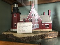
This lighthouse was built in 1875, standing at 201ft tall with a fixed white character. It is located 41 degrees North and 71 degrees West on Mohegan Bluffs, Block Island with a stream siren as its fog signal.
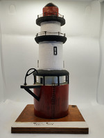
Point Judith Lighthouse - Model
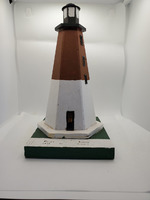
This lighthouse was built in 1810, standing at 67ft tall with a flashing white character. It is located at 41 degrees North and 71 degrees West with a siren for its fog signal.
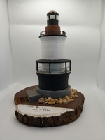
Castle Hill Lighthouse - Model
This lighthouse was built in 1890, standing at 40ft tall with a flashing red character. It is located at 41 degrees North and 71 degrees West on West side of Castle Hill with a bell for its fog signal.
Musselbed Shoals Lighthouse - Model
This lighthouse was built in 1873, standing at 33ft tall with a fixed red character. It is located 41 degrees North and 71 degrees West with a bell as its fog signal. Musselbed Shoals was maintained for 66 years until it was discontinued in 1939.
Whale Rock Lighthouse - Model
This lighthouse was built in 1882, standing at 71ft tall with a fixed red character. It is located at 41 degrees North and 71 degrees West on Whale Rock with a bell for its fog signal. Whale Rock was maintained for 56 years until it was discontinued…
Conanicut Point Lighthouse - Model
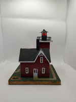
This lighthouse was built in 1886, standing at 45ft tall with a fixed red character. It is located at 41 degrees North and 71 degrees West, North end on Conanicut Island. Conanicut Point was maintained for 47 years until it was discontinued in 1933.
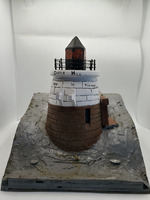
Plum Beach Lighthouse -Model
This lighthouse was built in 1897, standing at 53ft tall with a flashing white character. It is located 41 degrees North and 71 degree West on Plum Beach Shoal with a bell for its fog signal. Plum Beach was maintained for 44 years until it was…
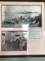
Record Bass Caught in Jamestown, RI
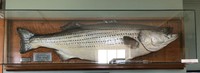
This bass was caught by A. S. Clarke on Oct. 22, 1936, weighing 65lbs. As of this writing (2021), it still holds the record for the largest striped bass ever caught from the shore.
It weighed in at 65 pounds.
The fish was restored by John P. Lopes,…
Sportfishing at Beavertail
This record-breaking striped bass was caught by Arthur S. Clarke of Jamestown on the afternoon of October 22, 1936. He was fishing from Flat Rock at nearby Hull's Cove. The fish weighed 65 lbs, measured 54 inches in length and 33 inches around the…
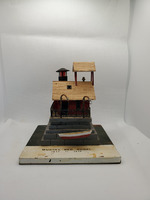
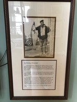
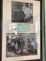
Keepers and their Families & Sabin Point Lighthouse
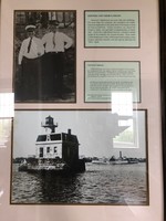
America's lighthouses are more than just buildings. For more than two centuries the usefulness of a lighthouse has depended on the dedication of its keeper to tend the beacon faithfully. Family members, too. shared the keeper's duties and provided…
Watch Hill Lighthouse
Richard Fricke was a lighthouse keeper for 27 years at stations including Point Judith, Latimer Reef, and Watch Hill. Richard and his stepson, Fred Buckley, received a citation from the United States government for the rescue of a canoeist who had…
Block Island Southeast Light
Jean Napier remembers Block Island's Southeast light as the place where her great-grandfather. Henry Clark. and grandfather, Willett Clark, were the first and second keepers. They tended the light from 1875 until 1932
"Grandfather would go out…
Lighthouse Locations in Rhode Island
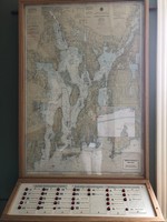
An interactive display showing the locations of Rhode Island Lighthouses. When a button is pressed a corresponding light on the map will indicate the location of the selected lighthouse.
The current display was built by Varajoun Karentz to replace…
Nautical Chart of Rhode Island (Narragansett Bay)
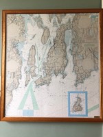
The LED lights embedded in this chart represent the lighthouses around Narragansett Bay.
The LEDs blink at the same rate as the actual lights.
This chart was donated by Carl Welshman of Harbor Lights Inc.
1855 sketch of Beavertail Lighthouse Grounds and Buildings
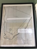
1855 sketch of the Lighthouse Grounds and Buildings at Beaver Tail Lighthouse, RI.
This map was drawn before the present tower was built.
Site of Horse Powered Fog Signal (1851)
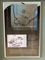
Poster showing the location of the horse powered fog signal at Beavertail in 1851
Horse Powered Treadmills (19th Century)
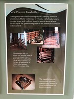
Horsepower treadmills during the 19th century were not uncommon. Many were used to power a variety of pumps, presses, saws, and tools on farms in remote areas where electricity or the gasoline engine was not available.
Shipwrecks in Narragansett Bay
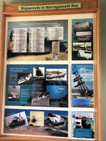
Storyboard displaying various shipwrecks occurring on Narraganset Bay over the years.
Brenton Reef Lightship Model
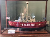
This model ship was of the Lightship Brenton LV102, which was stationed off Brenton Reef and was active from 1935 until 1962.
The Brenton Lightship model was created by Varjouran Karentz in 2018.
Tower Spiral Staircase Support Bracket

This is one of the 49 cast iron tread support brackets installed in1856 when the present tower was built. Over 150 years the stresses of settlement have caused a few of the weldments to snap.Modem engineers have determined that the tread supports…